Did you know?
- Since 1880, global sea level has risen about eight inches. Scientists expect global sea level to rise another one to eight feet by 2100.
- In 2010, 39% of the total population in the United States lived in counties along the coast. This population is expected to increase by 8% by 2020.
- 13 of the largest airports in the United States have at least one runway with an elevation within the reach of a moderate to high storm surge.
- Oceans can absorb 1000 times the amount of heat as the atmosphere.
Global sea levels are rising at an accelerating rate, and a changing climate is likely to speed up the rate of sea level rise over the next century. Before 1900, sea levels changed very little. From 1900 to 1992, sea levels rose at a rate of 0.04 to 0.1 inches per year. Since 1992, sea levels have risen at a rate roughly twice that observed over the last century. Over the past five years, global sea levels have risen by an average of one inch. One inch might not seem like much, but every inch of sea level rise covers 50-100 inches of beach.
Current and projected increases in sea level rise are related to warmer air and ocean temperatures. Warmer air increases melting of land-based ice, including glaciers and polar ice caps, increasing the flow of water into the oceans. Additionally, oceans absorb roughly 90% of the heat from a warming climate. Warming ocean temperatures cause sea levels to rise through thermal expansion – as water warms, it increases in volume.
Coastal areas in the United States face many risks associated with rising sea levels and some areas are more vulnerable than others. These risks include increases in urban flooding, sewer overflows, deteriorating coastal habitats and water quality, salt water contamination of drinking water and human health impacts. For example, the Biscayne Aquifer at the southern tip of Florida is the primary water source for the Florida Keys, Miami and the lower east coast of Florida. As sea level rises, saltwater intrusion into the aquifer will increase, which can make the water too salty for human consumption.
When coupled with intense storms, sea level rise will also result in more dramatic storm surges and related damages to infrastructure, including ports, oil and gas structures, roads, airports and bridges. Off the coast of New York City, sea levels rose a foot over the last century. When Hurricane Sandy hit, the flooding and associated damages to infrastructure and communities were more intense than they would have been a few decades ago.
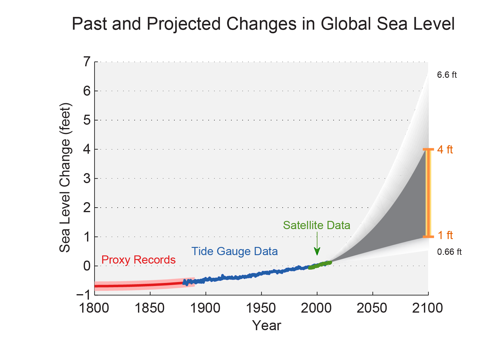
The figure above from the National Climate Assessment shows estimated, observed and possible future amounts of global sea level rise from 1800 to 2100, relative to the year 2000. Estimates from proxy data (for example, based on sediment records) are shown in red, tide gauge data are shown in blue for 1880-2009, and satellite observations are shown in green from 1993 to 2012. The orange line at right shows the currently projected range of sea level rise of one to four feet by 2100, which falls within the larger risk-based scenario range. The large projected range reflects uncertainty about how glaciers and ice sheets will react to the warming ocean, the warming atmosphere, and changing winds and currents. As seen in the observations, there are year-to-year variations in the trend. (Figure source: Adapted from Parris et al. 2012 5 with input from NASA Jet Propulsion Laboratory).
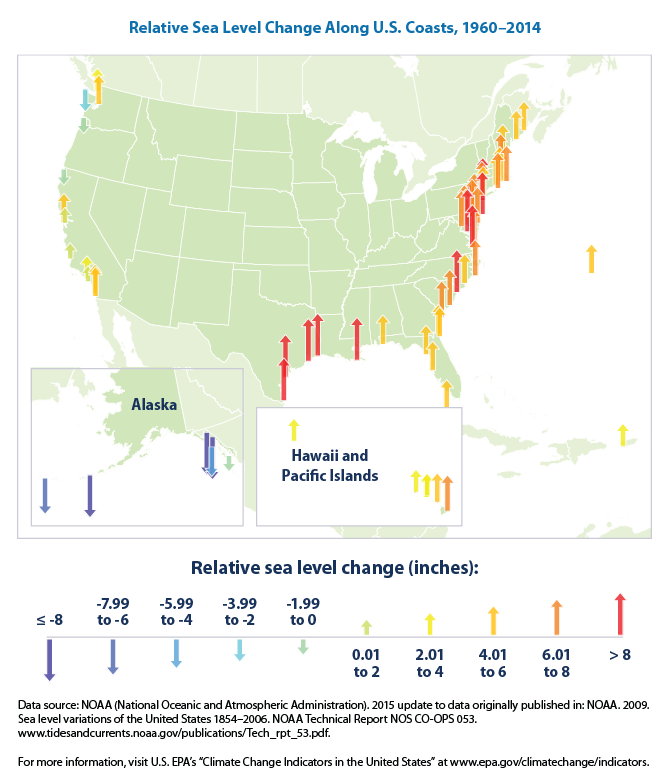
The figure below from EPA's Climate Change Indicators in the United States shows how sea level changed in various locations throughout the United States from 1960 to 2014.
Sources:
- Melillo, Jerry M., Terese (T.C.) Richmond, and Gary W. Yohe, Eds. 2014. Climate Change Impacts in the United States: The Third National Climate Assessment. Washington: U.S. Global Change Research Program. http://nca2014.globalchange.gov/.
- NASA. 2015. "Climate Kids Planet Health Report: Sea Level." Accessed September 17, 2015. http://climatekids.nasa.gov/health-report-sea-level/.
- NASA. 2015. "Vital Signs of the Planet: Sea Level." Accessed September 17. http://climate.nasa.gov/vital-signs/sea-level.
- NOAA. 2018. Tracking Sea Level Rise and Fall. Accessed April 4, 2020. https://www.noaa.gov/explainers/tracking-sea-level-rise-and-fall
- NOAA. 2009. "Sensistive to Sea-level Rise? New Report Sheds Light." Accessed September 17, 2015. http://oceanservice.noaa.gov/news/weeklynews/jan09/sealevelrisereport.h….
- NOAA. 2012. "Superstorm Sandy and Sea Level Rise." Accessed September 17, 2015. https://www.climate.gov/news-features/features/superstorm-sandy-and-sea….
- NOAA. 2014. "Ocean Facts." Accessed September 17, 2015. http://oceanservice.noaa.gov/facts/population.html.
- US EPA. 2015. "Climate Change Indicators in the United States: Sea Level Rise." Accessed September 17. http://www.epa.gov/climatechange/science/indicators/oceans/sea-level.ht….
- US EPA. 2015. "Climate Impacts on Water Resources." Accessed October 15.http://www3.epa.gov/climatechange/impacts/water.html